NATIONAL INSTITUTE FOR TRANSPORTATION AND COMMUNITIES
Executive Summary
As cities move to increase levels of bicycling for transportation, many practitioners and advocates have promoted the use of protected bike lanes (also known as “cycle tracks” or “protected bikeways”) as an important component in providing high-quality urban infrastructure for cyclists. These on-street lanes provide more space and physical separation between the bike lane and motor vehicle lane compared with traditional striped bike lanes. However, few U.S. cities have direct experiences with their design and operations, in part because of the limited design guidance provided in the past. Until recently there was limited research on protected bike lanes in North American. Researchers have been working to make up for this shortfall, with findings suggesting that protected bike lanes can both improve bicyclists’ level of comfort and safety, and potentially increase the number of people cycling.
Our research evaluates protected bike lanes in
five distinct contexts varying in population,
driving and cycling rates and cultures, and
weather: Austin, Texas; Chicago, Illinois; Portland,
Oregon; San Francisco, California; and,
Washington, District of Columbia (see map,
Figure 1). These five cities participated in the
inaugural “Green Lane Project” (GLP) sponsored
by People for Bikes (formerly known as Bikes
Belong).
This evaluation focused on six questions:
1. Do the facilities attract more cyclists?
2. How well do the design features of the facilities work? In particular, do both the users of the
protected bicycle facility and adjacent travel lanes understand the design intents of the
facility, especially unique or experimental treatments at intersections?
3. Do the protected lanes improve users’ perceptions of safety?
4. What are the perceptions of nearby residents?
5. How attractive are the protected lanes to different groups of people?
6. Is the installation of the lanes associated with measureable increases in economic activity?
Study Sites
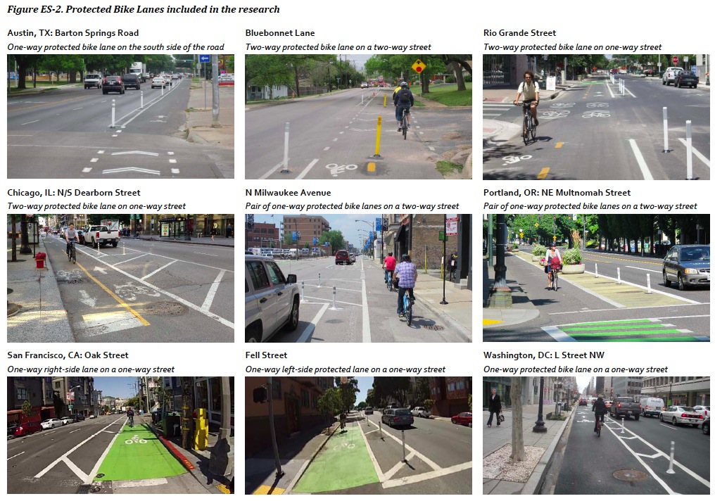
The study includes nine new protected bike lanes in the five cities (Figure ES-2 and Table ES-1).
The projects were completed between spring 2012 and summer 2013.
Austin, Texas
The Barton Springs Road protected bike lane is a one-way, half-mile long lane separated by flexposts and a 1.5’ buffer. Space was created by narrowing the motor vehicle lanes. There is a shared-use path on the other side of the street.
The Bluebonnet Lane protected bike lane is a two-way lane on a low-traffic primarily residential two-way street with an elementary school. The 0.7 mile lane is separated by flexposts and a 2’ buffer, and provides an alternative commuter route to the busy Lamar Boulevard. On-street parking was removed to provide room for the protected lane.
The Rio Grande Street protected bike lane is a two-way, half-mile long lane on the left side of a one-way street a few blocks the University of Texas-Austin campus. The street has a mix of residential, retail, and office uses. A motor vehicle lane and limited on-street parking were removed to provide room for the protected lanes and 4’ buffer with flex-posts.
Chicago, Illinois
The Dearborn Street protected bike lane is a two-way lane on a one-way street through Chicago’s ‘Loop.’ One motor vehicle lane was removed to provide space for the lane, which is separated by parking, flex-posts, and a 3’ buffer zone, with bicycle signals at each intersection.
The N. Milwaukee Avenue protected bike lanes, along a major radial route between central Chicago with neighborhoods to the northwest connect existing protected bike lanes on W. Kinzie Street and N. Elston Avenue. The protected bike lanes are on both sides of the street along the 0.8 mile route, buffered by a mix of a 2-3’ painted buffers with posts and parking protected areas.
Portland Oregon
The NE Multnomah Street protected bike lanes run 0.8 miles along a commercial street. The fivelane street with standard bike lanes and no on-street parking was “dieted” down to one travel lane in each direction, a two-way left-turn lane, and bike lanes protected by a mix of parking, painted buffers, flexible bollards, and/or planters, depending on the road segment.
San Francisco, California
The Oak and Fell Street protected bike lanes run three blocks along a one-way street couplet, connecting bike routes from downtown to Golden Gate Park and neighborhoods to the west. Parking was removed to accommodate the lanes with 5’ buffers and flex-posts.
Washington, District of Columbia
The L Street protected bike lane is half of a planned protected bike lane couplet along two one-way streets in downtown. L Street was decreased from 4 to 3 motor vehicle lanes in places, to make room for the 1.12-mile long, one-way left-side lane separated by a 3’ striped buffer zone with plastic flex-posts.

Download full version (Registration Required): Lessons from the Green Lanes
About the National Institute for Transportation and Communities
otrect.us/NITC
“The National Institute for Transportation and Communities, or NITC, is a program of OTREC at Portland State University and one of 22 university transportation centers designated by the U.S. Department of Transportation. Portland State leads the program in partnership with the University of Oregon, Oregon Institute of Technology, the University of Utah and the University of South Florida.”
Tags: Bicycling, Bike Lanes, Cycling, Flex Posts, National Institute for Transportation and Communities


 RSS Feed