LOUISIANA TRANSPORTATION RESEARCH CENTER
Introduction
Road flooding is a serious operational hazard for the many low-lying areas across southern Louisiana. The consequences are especially acute during hurricane season when emergency evacuation routes must be clear to allow for the safe evacuation of coastal residents ahead of an incoming storm. To mitigate the risk of flooding during hurricanes, emergency managers and decision-makers use situational awareness to acquire a synoptic understanding of the key factors and conditions that contribute to inundated roads.
Several hazards are associated with road flooding. The first identifies the flood risk relative to a vehicle type. This requires an assessment of the conditions in which flooding becomes a travel hazard. Such conditions include the relationship between the flood depth and velocity and the vehicle’s weight, shape, and ground clearance. Additional hazards include the conditions that contribute to the flooding of land surfaces from hurricanes. Factors include tidal ranges, wave effects, wind speed, storm surge, and storm speed and direction. Many of these factors are deterministic and can be derived from available coastal weather services. Hurricane storm characteristics such as forward velocity, direction, intensity, and surge are deterministically modeled by the National Hurricane Center (NHC) and provided as a geospatial data product distributed for approaching storms at specified intervals.
Accordingly, a near real-time, data-driven decision support tool was developed as a proof of concept to evaluate the parameters and workflows that support mitigation and response strategies for state maintained routes vulnerable during hurricane induced flooding. This document details the scope, methodologies, and implementation requirements for deploying this tool at the LADOTD. It concludes with a summary of research and analysis for determining flood risk to vehicles relative to flood scenarios.
Methodology
In accordance with the scope and objectives established above, the techniques employed for this project have been organized into four primary development phases: (1) data collection and processing; (2) inundation modeling; (3) decision support tool implementation; and (4) assessment of vehicle vulnerability relative to flood risk.
Data Collection & Processing
The data requirements for computing and quantifying hurricane induced flood hazards over road segments are summarized accordingly:
- elevations of select LADOTD routes that are vulnerable to storm surge;
- hurricane induced storm surge estimates relative to storm intensity, forward velocity, direction, and tide stage;
- and links to real-time water level observations from water/tide gauges;
Road Data
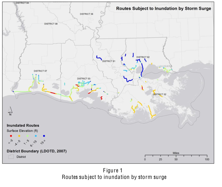
Inundation from hurricane induced storm surge was computed and quantified for select LADOTD roads, which were chosen due to their vulnerability to flooding.
Pavement Management System (PMS). State-maintained road survey data were provided by the LADOTD Pavement Management Systems (PMS), Section 21.
The road data was comprised of 4.42 million records stored within 13 Microsoft® Access databases. The data indicated publication during the first half of State fiscal year 2011. The databases represented the five LADOTD districts corresponding to the southern parishes of the state: Districts 02, 03, 07, 61, and 62. With the exception of District 61, three databases were provided for each district: frontage routes, off-system national highway system routes, and state maintained routes (e.g., Interstate, US, and LA). Only the state maintained routes database was provided for District 61. Table 5 in the appendix lists the attribute field names and descriptions that were provided with the PMS databases. Point features representing the PMS data were saved in an ArcGIS version 10.0 file geodatabase labeled, “LDOTD_PMS_2011.”
Routes Subject to Inundation by Storm Surge. A list of 88 routes identified as vulnerable to storm surge was provided by the LADOTD Office of Operations.
Read full report (PDF) here: Quantifying the Key Factors that Create Road Flooding
About the Louisiana Transportation Research Center (LTRC)
www.ltrc.lsu.edu
“Since its creation by the legislature in 1986, the Louisiana Transportation Research Center (LTRC) has grown to national prominence through its efforts to improve transportation systems in Louisiana. The center conducts short-term and long-term research and provides technology assistance, engineering training and continuing education, technology transfer, and problem-solving services to DOTD and others in the transportation community. The center is largely supported by funding authorized by the Federal Highway Administration. LTRC’s goal is to merge the resources of state government and universities to identify, develop, and implement new technology to improve the state’s transportation system. LTRC combines the efforts of DOTD and the state’s universities to find innovative solutions to Louisiana’s transportation problems.”


 RSS Feed