


Authors: Ramakrishnan Durairajan, Carol Barford, Paul Barford, University of Oregon, University of Wisconsin – Madison
Abstract
In this paper we consider the risks to Internet infrastructure in the US due to sea level rise. Our study is based on sea level incursion projections from the National Oceanic and Atmospheric Administration (NOAA) and Internet infrastructure deployment data from Internet Atlas. We align the data formats and assess risks in terms of the amount and type of infrastructure that will be under water in different time intervals over the next 100 years. We find that 4,067 miles of fiber conduit will be under water and 1,101 nodes (e.g., points of presence and colocation centers) will be surrounded by water in the next 15 years. We further quantify the risks of sea level rise by defining a metric that considers the combination of geographic scope and Internet infrastructure density. We use this metric to examine different regions and find that the New York, Miami, and Seattle metropolitan areas are at highest risk. We also quantify the risks to individual service provider infrastructures and find that CenturyLink, Inteliquent, and AT&T are at highest risk. While it is difficult to project the impact of countermeasures such as sea walls, our results suggest the urgency of developing mitigation strategies and alternative infrastructure deployments.
Introduction
Climate change is perhaps the most significant problem facing humanity. The dramatic rise in greenhouse gas concentrations in the atmosphere over the past 100 years is causing changes in weather patterns including increased likelihood of severe storms as well as rapid rise in sea levels due to melting polar ice caps and thermal expansion of seawater. These phenomena have important implications for the planet and the effects are already being felt in many areas.
To understand and prepare for the impacts of climate change, a number of models have been developed to project average sea level rise. The models are based on a variety of empirical parameters including sea level rise over the past 100 years and the geographic features of coastal areas. The models predict significant incursions on coastal areas that imply displacement of large human populations. In response, some of the threatened areas are already preparing mitigation plans, but holding back the oceans is a formidable undertaking to say the least.
With significant sea level rise predicted, it is important to assess the threat to communication infrastructure. An indication of the potential impacts are the storm surges of major hurricanes such as Katrina and Sandy that devastated communication systems. While the standard buried fiber conduits are designed to be water and weather resistant, most of the deployed conduits are not designed to be under water permanently.
In this paper, we make a preliminary analysis of the risks of climate change on Internet infrastructure. The goal of our work is to understand risks and potential impacts over timescales of decades, which is consistent with other work on climate change. Our specific interest in this paper is assessing how the rise in sea levels threatens buried fiber conduits and termination points (e.g., colocation facilities, point of presences (POPs), etc.) in coastal areas in the US. Our analysis is conservative since it does not consider the threat of severe storms that would cause temporary sea level incursions beyond the predicted average. Our analysis also does not consider any efforts to harden or fortify communication infrastructure since we argue that this will only be feasible in relatively small geographic areas.
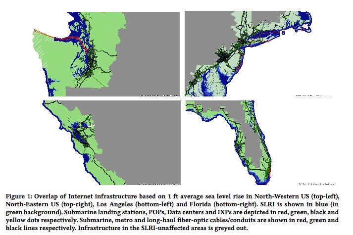
Our study is based on analysis of two data sets. The first is the communication fiber conduit and termination point data in Internet Atlas. The Atlas repository includes geocoded maps of over 1500 networks from around the world. The second is the Sea Level Rise Inundation (SLRI) data from NOAA’s Digital Coast project. This diverse dataset includes a collection of geo-based sea level rise projections for the US over the next century. We fuse the Atlas and SLRI datasets by translating them into a consistent shape format, and then analyze how sea levels will overlap communication infrastructure over successive time periods.
The results of our analysis show that climate change-related sea level incursions could have a devastating impact on Internet communication infrastructure even in the relatively short term. In particular, we find that 1,186 miles of long-haul fiber conduit and 2,429 miles of metro fiber conduit will be underwater in the next 15 years. Similarly, we find that 1,101 termination points will be surrounded by sea water in the next 15 years. Given the fact that most fiber conduit is underground, we expect the effects of sea level rise could be felt well before the 15 year horizon. Interestingly, we find that the risks over longer time scales do not increase significantly. Specifically, there is only a modest increase in the amount of additional Internet infrastructure that will be under water at the 6 ft. rise level (the 100 year projection) vs. the 1 ft. rise level (the 15 year prediction).
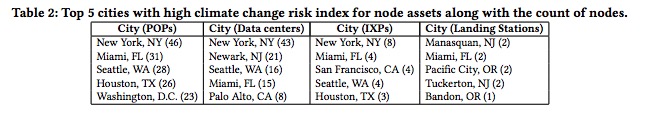
To assess the risk of sea level incursions in specific geographic areas, we define the Coastal Infrastructure Risk (CIR) metric that considers the combination of geographic scope and Internet infrastructure density. We use the CIR metric to examine coastal regions in the US with high population density. Our results show that communication infrastructure in New York, Miami, and Seattle, respectively, are at highest risk. We also quantify the impact to individual service providers and find that CenturyLink, Intelliquent (formerly Tinet), and AT&T are at highest risk. These results highlight where developing mitigation strategies and planning alternative deployments should begin in order to preserve both local and long haul assets.
Download full version (PDF): Climate Change Risk to Internet Infrastructure
Tags: Climate Change, Flooding, NOAA, Sea Level Rise, University of Oregon, University of Wisconsin - Madison
 RSS Feed