NORTH CAROLINA DEPARTMENT OF TRANSPORTATION
Introduction
 Shared use paths (SUPs), also known as greenways or trails, are unique facilities physically separated from motor vehicle traffic that allow a shared space in which bicyclists, pedestrians, and sometimes equestrian or other non-motorized users can travel. Often SUPs are constructed within an independent right-of-way and may follow a waterway, railroad, or utility corridor. Side-paths are a specific type of SUP that are constructed within a roadway right-of-way but are physically separated from motor vehicle traffic by a positive barrier. While some research has been conducted in North Carolina to understand the economic contribution that specific facilities like SUPs may have in a community,1, 2, 3, 4 North Carolina is lacking in a comprehensive approach to evaluate the economic returns currently being generated by existing trails of regional significance. The first step toward the goal of evaluating the collective contribution of SUPs in North Carolina is to develop a way by which greenways across the state can be uniformly assessed.
Purpose of Project
The North Carolina Department of Transportation (NCDOT) has supported the construction of many SUPs, in coordination with local governments within the state, since the 1970’s. With the creation of a data-driven process to prioritize transportation projects that began in 2013 and continues to evolve, independent bicycle and pedestrian projects such as SUPs are now evaluated, ranked, and compete with projects from all transportation modes. This objective, performance based prioritization process currently uses travel time savings and safety benefits based on crash history as the economic criteria, but these metrics fall short in fully accounting for the range of potential economic benefits of bicycle or pedestrian projects. This research lays a foundation toward a long-term goal of the NCDOT to create new metrics for economic-based performance that can ultimately aid non-motorized transportation projects to more fairly compete for funds.
Objective
 The objective of this project was to design and test a methodology for consistently evaluating the economic contribution of shared use paths in North Carolina. A comprehensive valuation framework was designed and tested based on a menu of economic impacts that were explored. These include considerations for understanding trail user and societal benefits (health, congestion reduction, pollution reduction, and safety benefits), business benefits (trip expenditures, retail sales tax benefits), and community benefits (capital expenditures, operational expenditures, property value impacts). Given that SUPs may have different characteristics, adjacent land uses, and local contexts, the methodology framework is flexible enough to allow one to measure different types of economic contributions as may be appropriate for the SUP under study. At the same time, the framework provides a standard for what and how data are collected and analyzed, given the specific economic benefit(s) of interest, so that, ultimately, datasets from different SUPs or regions can be compared or compiled to reflect a comprehensive understanding of the economic contributions of SUPs to the state of North Carolina.
Project Need
Historically, North Carolina has been known as the “Good Roads State,” due to the high quality and connectivity of its state roads system. There is a movement stirring to add a new moniker to North Carolina’s accolades by positioning itself as the “Great Trails State.” This project seeks to begin to quantify the economic contribution that SUPs provide through outdoor recreation and transportation options and how these activities may impact local and state economies through tourism, events, urban redevelopment, community improvement, property values, health care savings, jobs, investment, and general consumer spending.
Currently, much of North Carolina’s overall mileage of SUPs remains in the planning phase. While construction is occurring, the information gleaned through this project’s case studies will assist in understanding how these expenditures can lead to future economic growth in a community, and the findings may influence decisions for further investment in SUPs for the development of more extensive trails and networked systems across the state. Standard methods developed through this project will also assist in easier duplication of research efforts on economic contributions for other trails, trail segments, or networks. Additionally, as similar data are consistently collected and analyzed across the state, this project will allow NCDOT to ultimately pull datasets together to compare economic activity from SUPs across regions or understand statewide trends. For some of the SUPs studied through this project, the data collected and results compiled can now serve as “before data,” so that as these trails expand or connect to a larger network, the economic impacts from these changes can be assessed via “after” studies comparisons.
Overview of Study
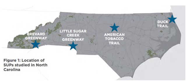
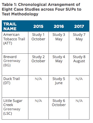
Four SUPs were selected to test the methodology. The American Tobacco Trail (ATT) in Durham and the Brevard Greenway (BG) in Brevard were studied iteratively for three years, while the Little Sugar Creek Greenway (LSC) in Charlotte and Duck Trail (DT) in Duck served as cross-sectional case studies. The iterative cases allowed for comparison of results across years to test the reliability of the methodology and potentially identify factors that may influence its application, such as seasonality. The additional cross-sectional cases provided a broader mix to test the methodology on different types of SUPs based on their land use contexts, user types, and expected trip purposes. This project structure allowed for eight separate studies to be conducted to test the methodology across three years, as shown in Table 1.
These four SUPs were identified through a selection process based on meeting a series of criteria. Besides reflecting a geographical spread across the state as shown in Figure 1, these trails vary in length, visitor usage, and rural or urban context, while having similar other characteristics as defined by the selection criteria, such as being well established SUPs that demonstrate an ability to have a transportation function.
The methodological framework allowed for an “a la carte” selection of types of economic impact to analyze for each study, given variation in the trails. For example, due to the narrow, barrier island geography of the Outer Banks, the prevalence of vacation home properties, and the trail’s close proximity to the beach, the Duck Trail’s economic impact on property values would be extremely difficult to tease out. Figure 2 shows the menu of economic benefits analyzed based on three primary categories of business, community, and user benefits.
Download full version (PDF): Evaluating the Economic Impact of Shared Use Paths in North Carolina
About the NC DOT Division of Bicycle & Pedestrian Transportation
www.ncdot.gov/bikeped
NCDOT’s Division of Bicycle and Pedestrian Transportation (DBPT) is one of the oldest programs of its kind in the nation, established in 1973. DBPT seeks to integrate bicycle and pedestrian safety, mobility and accessibility into the overall transportation program through engineering, planning, education and training.
Tags: Bicycling, Bike Paths, Cycling, NC, NC DOT Division of Bicycle & Pedestrian Transportation, NCDOT, North Carolina, North Carolina Department of Transportation, Pedestrian, Shared Use Paths, SUPs


 RSS Feed