GEOLOGICAL SOCIETY OF AMERICA
Abstract
Today, relative sea-level rise (3.4 mm/yr) is faster in the Chesapeake Bay region than any other location on the Atlantic coast of North America, and twice the global average eustatic rate (1.7 mm/yr). Dated interglacial deposits suggest that relative sea levels in the Chesapeake Bay region deviate from global trends over a range of timescales. Glacio-isostatic adjustment of the land surface from loading and unloading of continental ice is likely responsible for these deviations, but our understanding of the scale and timeframe over which isostatic response operates in this region remains incomplete because dated sea-level proxies are mostly limited to the Holocene and to deposits 80 ka or older.
To better understand glacio-isostatic control over past and present relative sea level, we applied a suite of dating methods to the stratigraphy of the Blackwater National Wildlife Refuge, one of the most rapidly subsiding and lowest-elevation surfaces bordering Chesapeake Bay. Data indicate that the region was submerged at least for portions of marine isotope stage (MIS) 3 (ca. 60–30 ka), although multiple proxies suggest that global sea level was 40–80 m lower than present. Today MIS 3 deposits are above sea level because they were raised by the Last Glacial Maximum forebulge, but decay of that same forebulge is causing ongoing subsidence. These results suggest that glacio-isostasy controlled relative sea level in the mid-Atlantic region for tens of thousands of years following retreat of the Laurentide Ice Sheet and continues to influence relative sea level in the region. Thus, isostatically driven subsidence of the Chesapeake Bay region will continue for millennia, exacerbating the effects of global sea-level rise and impacting the region’s large population centers and valuable coastal natural resources.
Introduction
The sea level for any location at a given point in time represents a sum of factors, including the volume of ocean water, steric (thermal) effects, tectonic activity, and crustal deformation in response to glacio-hydro-isostatic adjustment (GIA) from loading and unloading of continental ice and water masses (Church et al., 2010). GIA can be a dominant driver of relative sea level (RSL) near ice margins, where the weight of ice displaces the mantle beneath glaciated regions, uplifting a “forebulge” in the peripheral, non-glaciated region (Peltier, 1986). With ice retreat, the forebulge progressively subsides at rates dependent on mantle rheology and lithosphere thickness (Peltier, 1996).
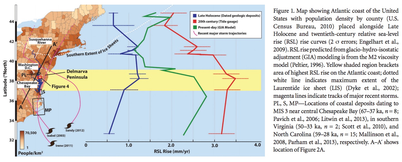
GIA played a role in RSL near the Chesapeake Bay region of the United States (Fig. 1) for many millennia after the ice melted away (Peltier, 2009). GIA effects were first recognized in the region when shoreline deposits ~3–5 m above present sea level, long assumed to be ca. 125 ka (marine isotope stage [MIS] 5e; MIS designations from Lisiecki and Raymo, 2005), were found to have ca. 80 ka ages (MIS 5a; Cronin, 1981). During this time, global average sea level was as much as 20 m below its present level (Fig. 2). While flexural isostatic uplift and subsidence have been documented in the Chesapeake Bay region (i.e., Pazzaglia and Gardner, 1993), the rates (~0.006 mm/yr) associated with these processes are insufficient to account for the age-elevation relationships of MIS 5a shorelines.
The presence of MIS 5a shorelines 3–5 m above present sea level indicates that the land surface within the Chesapeake Bay region was significantly lower during the formation of these shorelines due to regional land subsidence from the collapse of the MIS 6 forebulge, and that the Chesapeake Bay region experienced renewed forebulge uplift during the MIS 2 to raise these shorelines above present sea level (Potter and Lambeck, 2003; Wehmiller et al., 2004). The Holocene stratigraphic record in the Chesapeake Bay region helps illuminate forebulge dynamics; differential subsidence from the collapse of the MIS 2 forebulge caused variable timing and rates of inundation along the eastern seaboard during the Holocene transgression (Peltier, 1996). These differential rates have been exploited to reconstruct the form of the forebulge (Engelhart et al., 2009) and to constrain GIA models (Fig. 1) (Davis and Mitrovica, 1996; Peltier, 1996).
Recent studies employing optically stimulated luminescence (OSL) dating suggest that the lowest-elevation, emerged estuarine deposits within the mid-Atlantic were deposited during MIS 3, significantly extending the inferred duration and magnitude of land subsidence due to collapse of the MIS 6 forebulge. Shoreline landforms above sea level (<8 m above mean sea level [asl]) near central Chesapeake Bay (PL, Fig. 1), at the mouth of Chesapeake Bay (S, Fig. 1), and on the North Carolina coast (MP, Fig. 1) indicate estuarine deposition throughout MIS 3 (67–32 ka). Eustatic sea level during this time was highly variable but always ~40–80 m lower than present (Fig. 2) (Siddall et al., 2008). These new data challenge the long-held implication that locations within the Chesapeake Bay region, and specifically the Delmarva Peninsula, did not experience high-stand deposition after MIS 5 (e.g., Ramsey, 2010). The presence of near-shore MIS 3 deposits near present sea level suggests an alternative sea-level history for the region, one that implies forebulge uplift of at least 40 m since the time of deposition. This uplift has been attributed to growth of the last glacial maximum (LGM; MIS 2) forebulge (Pavich et al., 2006; Mallinson et al., 2008; Scott et al., 2010; Parham et al., 2013) that remains uplifted out of isostatic equilibrium (Potter and Lambeck, 2003).
This paper uses multiple methods to date deposits within the zone of greatest subsidence in the Chesapeake Bay region (Fig. 1) and place today’s rapid relative sea-level rise into the context of a several-million-year geologic framework. We used a light detection and ranging (LiDAR) digital elevation model (DEM) to analyze low-relief landforms and conducted extensive drilling to constrain the Pleistocene stratigraphic framework. Our data show that regional subsidence related to collapse of the MIS 6 glacioisostatic forebulge impacted the mid-Atlantic region well into MIS 3, tens of thousands of years after MIS 5 deglaciation. Long-lasting subsidence associated with collapse of the MIS 6 forebulge suggests that present-day subsidence related to the collapse of the MIS 2 forebulge will continue for the foreseeable future. We conclude that ongoing subsidence adds to the impacts of sea-level rise driven by warming climate and melting ice sheets and should be considered in coastal sea-level risk assessments.
About the Geological Society of America
www.geosociety.org
Established in 1888, The Geological Society of America® provides access to elements that are essential to the professional growth of earth scientists at all levels of expertise and from all sectors: academic, government, business, and industry…The Society’s growing membership unites thousands of earth scientists from every corner of the globe in a common purpose to study the mysteries of our planet (and beyond) and share scientific findings.
Tags: Chesapeake Bay, Flooding, Geological Society of America, GSA, Melting, Sea Level Rise, Washington DC


 RSS Feed