BROOKINGS INSTITUTION
Introduction
The worsening financial state of the federal, state, and local governments is a frequent subject in media and political circles. As discretionary expenditures, transportation programs likely face significant changes if they are to cope with spending cuts across all levels of government. These changes would require not only reprioritizing the use of scarce funds, cutting ineffective programs, and improving the performance of remaining programs, but also encouraging states and local partners to find other sources of funding for transportation.
Measuring accessibility is an essential tool in such a makeover because it reveals the benefits of a transportation system. Accessibility is the ease of reaching valued destinations, such as jobs, shops, schools, entertainment, and recreation. As such, accessibility creates value. Capturing some of this value would allow state and local governments to invest in the operations, maintenance, and in some cases expansion of their transportation networks. Accessibility, as an outcome-oriented metric, can effectively assess transportation’s economic impact, and capturing the value of accessibility would help states and metropolitan areas develop sustainable transportation funding streams.
This study examines accessibility and its importance in assessing transportation performance and in creating a sustainable transportation funding source. It first delineates the concept of accessibility by comparing it with a common transportation performance metric, mobility. The paper then explains how accessibility can help fund transportation through a virtuous circle: infrastructure creates access, access creates value, and value can be captured to fund infrastructure. Although this paper uses evidence mainly from the Minneapolis–St. Paul metropolitan area, the final section provides policy recommendations for all levels of government involved in funding the U.S. transportation system.
Accessibility may be defined in different ways. However, the goal in measuring it is to use a measure that is clear to all constituents; cumulative from block to neighborhood to city to metropolitan area; comparable on the same scale and across multiple modes; comprehensive across different types of land use; and readily computed with available data. On the basis of these criteria, this study defines accessibility as the number of jobs that can be reached from a location (for example, a residence) by car or transit within 30 minutes during the morning peak hour (7:30 to 8:30 am).
Accessibility versus Mobility
The transportation problem is often posed as a mobility problem, in terms of ways of moving quickly on networks. As a result, concerns about congestion dominate and words such as “gridlock” pervade the media. Congestion was an important argument when the transportation network was undeveloped and demand far outstripped the road supply. During the past decade, data from the U.S. Federal Highway Administration suggests that the number of vehicle miles travelled (VMT) is flat and VMT per capita is declining, trends similar to those in other industrialized countries. Although the average level of traffic may be largely flat, in fast-growing areas, congestion problems continue to emerge. Value-capture strategies tie economic growth to infrastructure investment, and head off the consequences of inadequate public facilities.
Mobility measures the ease of moving on the network, and the travel time index—the ratio of travel time during congestion (in the peak period) to the travel time in uncongested conditions—is a common mobility proxy. Mobility is a significant issue in understanding how metropolitan areas and their transportation systems function. However, accessibility is a more complete measure because it considers not only mobility, but the other important problem: the location of activities. The concept of accessibility allows us to measure the efficiency of the metropolitan area in its primary role: enabling people to reach other people and places. A simple example illustrates the problem with considering only mobility.
Manhattan, Kansas, versus Manhattan, New York. Compare two Manhattans: Kansas and New York. The population of Manhattan, KS, “the Little Apple,” is almost 53,000 people, with a metropolitan area population of 123,000 spanning 1,888 square miles.11 The island of Manhattan, an area of 27.9 square miles, is home to more than 1.6 million people.
In Manhattan, KS, the home to Kansas State University, there is a relatively high network speed with virtually no congestion, which would produce a travel time index of barely above 1. The travel time index for New York–Newark, NY-NJ-CT urbanized area is 1.37, ranking it among the top five cities in the United States. The index would be even higher for the notoriously congested island of Manhattan. This means it takes at least 37 percent longer to travel the same distance in Manhattan, NY, than Manhattan, KS. That said, one can reach many more destinations in the same amount of time in New York because of the high population and job density on the island. In a half-hour drive from an average point in metropolitan New York, one can reach 1.3 million jobs in Manhattan, and even more if one considers transit. From the center of Manhattan, KS, one could reach about 64,000 jobs in 30 minutes. As a result, Manhattan, NY, is more than 20 times as accessible as Manhattan, KS, despite speeds that are, at best, half as fast. The differences in accessibility are reflected in highly dissimilar land prices. For example, the average office rent in Manhattan, NY, was approximately $52 per square foot, while in Manhattan, KS, it was about $10-28 per square foot.
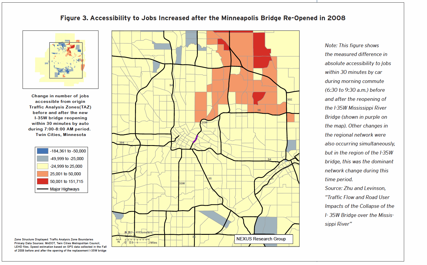
Typically, accessibility and congestion rise together, as more development, a cause of greater accessibility, also causes greater congestion. The evidence shows that it is possible for the accessibility increase from the ability to reach more destinations be larger than the accessibility decline from slower speeds associated with the traffic that development brings. For example, congestion in the Twin Cities region increased from 1995 to 2005, with the number of hours of delay per peak traveler rising from 31 to 43 per year. In the same time, this metropolitan region was more accessible in 2005 than 1995, with more jobs that could be reached in the same amount of time despite the rise in congestion. This joint increase in congestion and accessibility was the result of some additional roadway capacity, more intense use of faster roads, and the movement of jobs to lower-density suburban centers.
The decentralization of employment in Minneapolis–St. Paul, similar to other large metropolitan areas, is the driving force behind these seeming paradoxes of higher congestion and greater accessibility. The suburbanization of jobs follows decades of suburbanization of people, with most of the region’s new residents moving into suburban locations between 1995 and 2005. An improved balance of accessibility to jobs and workers reflects this convergence phenomenon and indicates that employers respond to accessibility, as determined by network configuration and pre-existing land use (especially residential) (Figure 1). Firms take into account accessibility when they decide where to locate in an effort to be close to labor pools and reduce their labor costs.
The additional roadway capacity and more intense use of faster suburban roads between 1995 and 2005 contributed to a higher average network speed along with rising congestion in the Twin Cities region. When drivers switch from slow roads to faster roads (such as suburban highways) on the same network, the average speeds on each road segment may decline, resulting in congestion, but the overall network speed may nevertheless increase. Table 1 shows this phenomenon.
In Table 1, the speed drops on both links of the network after more drivers switched from the congested road to the faster road, while the system average speed rose to 30 miles per hour from 28. Although both roads got more crowded, the relatively faster route attracted more travelers. This example illustrates what happens in metropolitan areas around the country where the decentralization of employment leads more travelers (and more important, a greater share of travelers) to switch to faster suburban highways from congested urban arterials.
Download full version (PDF): Access for Value
About Brookings Institution
www.brookings.edu
“The Brookings Institution is a nonprofit public policy organization based in Washington, DC. Our mission is to conduct high-quality, independent research and, based on that research, to provide innovative, practical recommendations that advance three broad goals:
* Strengthen American democracy;
* Foster the economic and social welfare, security and opportunity of all Americans and
* Secure a more open, safe, prosperous and cooperative international system.
Brookings is proud to be consistently ranked as the most influential, most quoted and most trusted think tank.”
Tags: Accessibility, Brookings Institution, David M. Levinson, Emilia Istrate


 RSS Feed